I was asked in another thread why an iPhone on an electric bike.....
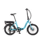
Our bikes have a IP address and WiFi board on the conroller. Thus it is a simple matter to interface an iPad or an iPhone using an App to the bike. Equally, using a USB to CANbus connector, we can interface a laptop to the bike.
Through either mechanism, we can change the power profile of the bike - attack, max amps, max speed, role of throttle etc etc.
Using the iPhone, in the pocket or mounted on the handlebars, the user can control these parameters if they wish to change the power profile mid journey.
But that is only 10% of the story. The GPS / Altitude capability of the iPhone, and the accelerometer, give us the ability to build up a data log history of a bike ride. Through the network, the iPhone can interrogate the bike and store data from any of the bike sensors - spped, brake usage, Amps, cadence, torque (differential pedal to pedal), ambient light, temperature. Being CANbus it is trivial to add sensors to monitor such as heartbeat, skin conductivuty, respiration rate. All can be recorded in real time via the wireless by the iPhone.
When you get home, the journey log can be mashed with Google Earth or sent by email to other users.
So, considering just two applications as this is becoming a long post:
A. I want to see how my fitness as a commuter is improving as I use my bike on the same route day after day. I can build up a 3D stack of journeys, with date being the third axis, and see how I am using less and less battrery as I get fitter. I can also look at the points I use most amps, and refine my power profile to avoid such usage and encourage myself to ride harder at those hot points.
B. I am an orthopedic surgeon at a hospital which has leased a fleet of bikes. I lend them to my recovering patients with instuctions to do a set of carefully prescribed different journeys, one each day, they will hopefully follow the navigation I have sent them as GPS routes by email, and at the end of each week, they send me their journey logs. I can see if they have actually being doing the trips I wanted. I can see how much work their two kness have differentially done.
I also was challenged quite reasonably on the use of GPS for altitude and the errors in it. Actually I find my HTC desire more accurate than the iPhone. However, the errors are small and tend to be due to calibration rather than accuracy - thus elevation achieved (difference between two iPhone altitudes) is accurate to about 5%
- even if the baseline is way out.
GPS altitude is usually x1.5 the horizontal error, so an EPE of 2m would give an altitude EPE of 3m. However, these errors tend to be on the same side over a 20 minute period - so difference between elevations are less than that.
GPS altitude is computed above the WGS-84 Geoid (WGS-84 is the reference coordinate system used by the Global Positioning System) which is not necessarily perfectly accurate with respect to the ground around you. It is not be the OS standard used for altitude measurement.
However, the key thing is we use the altitude held by Google maps as a primary data source when we mash, and the GPS realtime as secondary.
Prizes for anyone who comesa up with a novel use for an iPhone wireleseely linked to an electric bike....