Elevation based cycle route planner?

Beach Thorncombe

Pedelecer
Dec 15, 2016
127
47
United Kingdom
Hi,

I’m aware of cycleroute.org, (currently out of service) and Google Maps cycle mode but can anyone recommend or provide a net link, (or Android app link), for an application that can intelligently offer alternate routes to circumnavigate or work around hills on an entered original route.

I’m not interested in apps or sites that merely show profile elevation of an entered route. I’d prefer an application that can automatically calculate routes to iron out hills or promontories.

I currently enjoy my own West Dorset hills and have little issue in navigating them but this request is based on seeking an efficient route from A to B if, for example, I wished to deduce the least hilly route to travel from Bridport to Yeovil or Bridport to Axminster or Dorchester.

I don’t need lists of arithmetic or geometry. I just need a recommendation, (a link or an app), that might meet my needs.

Thanks.

I want to plan routes of up to 20 miles, without putting more strain on my, (reasonably fit but failing), 60 year old body than my doctor would recommend.

Thus … can anyone point me to a useful, elevation based cycle route planner that accomodates or works around hills?

Alternately, has anyone come across a decent, online based, sea level map tool that floods a 3d Google Earth style map … to achieve a similar, though only visual, version of a ‘hill avoider’.
 
Last edited:
  • Like
Reactions: LeighPing

Beach Thorncombe

Pedelecer
Dec 15, 2016
127
47
United Kingdom
I've just found bikehike.co.uk and, although it doesn't meet the needs I requested above, it does have a very nice interface ... showing elevation / gradient / ascent / descent/ mileage etc ... with a map that zooms in and out alongside an elevation profile that shows an icon, (representing a bicycle or car), in great detail.

I suppose, if pushed, I could break a planned journey down into little sections and manually plot a route to avoid large inclines or hills though, while bikehike.co.uk greatly helps with such a process, it won't automatically do such a thing by itself ... and anyway, knowing the routes quite intimately already, I can, just about, see my way around hills by merely using my eyes and imagination.

In a perfect world, I'd be able to utilise a comprehensive map showing user defined routes offering the perfect collection of roads, paths and trails to efficiently travel from A to B but, so far, I've been unable to locate such a thing.
 
D

Deleted member 4366

Guest
I've just found bikehike.co.uk and, although it doesn't meet the needs I requested above, it does have a very nice interface ... showing elevation / gradient / ascent / descent/ mileage etc ... with a map that zooms in and out alongside an elevation profile that shows an icon, (representing a bicycle or car), in great detail.

I suppose, if pushed, I could break a planned journey down into little sections and manually plot a route to avoid large inclines or hills though, while bikehike.co.uk greatly helps with such a process, it won't automatically do such a thing by itself ... and anyway, knowing the routes quite intimately already, I can, just about, see my way around hills by merely using my eyes and imagination.

In a perfect world, I'd be able to utilise a comprehensive map showing user defined routes offering the perfect collection of roads, paths and trails to efficiently travel from A to B but, so far, I've been unable to locate such a thing.
Woosh used to have a nice route planner on their website. It highlighted all the steep hills. See if it's still there.
 

Woosh

Trade Member
May 19, 2012
19,529
16,466
Southend on Sea
wooshbikes.co.uk
Woosh have a tool that may do what you want, if you use it on a desktop or a large tablet, you won't be able to drag the route well on a small smartphone.
We call it the predictor.
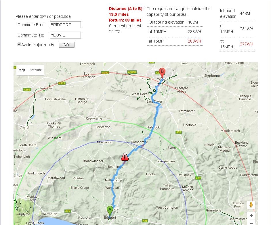
You enter your home location, Bridgport in your example, or your postcode. Click Go. The tool will draw an area about 50 miles around your home location. Move and zoom the map to suit the area you are interested in. Now click on where you want to go, in this case, Yeovil.
The tool will plot a cyclable route between the two locations and guestimate the battery requirement for the outbound trip. Some of the route is highlighted in red. They are steep bits.
Zoom into the section that has a red warning triangle, that's where the steepest bit is.In your example, that will be North East of Bearminster.
Now move the mouse over the plot (ie the plotted route) until you see the cursor changing into a hand. Hold down the left mouse button and drag the route over to Crewkerne. The plot now changes, the steep bit NE of Bearminster is now gone. The tool will recalculate the new route requirements for you.
If you want the local info, move the mouse over the elevation profile below the map. The code will draw a marker on the elevation profile and display a flag along the plot.
The local info - including local gradient, is displayed just below the elevation profile.
 

Beach Thorncombe

Pedelecer
Dec 15, 2016
127
47
United Kingdom
Thanks for the details, Woosh. That sounds very close to what I am looking for.

I'd actually just tried the Predictor but it didn't like my mode of input re postcodes. I tried lower case, upper case, with and without space between first and second part of postcode but it kept asking me to try again.

I'll try again now.

Cheers
 

Woosh

Trade Member
May 19, 2012
19,529
16,466
Southend on Sea
wooshbikes.co.uk
case does not matter. I enter BRIDPORT or DT6 3AA for example, then click GO. You can enter both locations, A and B before clicking GO.

 
  • Like
Reactions: Beach Thorncombe

Beach Thorncombe

Pedelecer
Dec 15, 2016
127
47
United Kingdom
Thanks D8veh. Thanks Woosh.

Predictor is very interesting / useful.

I'm currently using it on a mediocre laptop I happen to be servicing but will try again on my quad PC to get a swifter, slicker experience tomorrow.

Typing location, (rather than entering post codes), works best for me.
 

Beach Thorncombe

Pedelecer
Dec 15, 2016
127
47
United Kingdom
Out of interest ...

At what elevation or gradient does Predictor turn a point RED? Is it programmable?

Programmable or not, I like it and think it will work in harmony with bikehike.co.uk or similar, highlighting hills I should probably avoid.
 

Woosh

Trade Member
May 19, 2012
19,529
16,466
Southend on Sea
wooshbikes.co.uk
Thank you Beach. The red bits are where the gradient is 8% and above.
 

danielrlee

Esteemed Pedelecer
May 27, 2012
1,349
691
Westbury, Wiltshire
torquetech.co.uk
Try cyclestreets.net, or their standalone Android app 'CycleStreets'. It does take into account elevation when calculating routes, although I don't think the algorithm used is customisable.
 

Woosh

Trade Member
May 19, 2012
19,529
16,466
Southend on Sea
wooshbikes.co.uk
Apps are dinosaurs. Javascript is the way to go.
The Woosh Predictor is written in non-obfuscated Javascript.
 

Advertisers