calibrated digital inclinometer? Are these readily available and reasonably priced? I could use a new gadget!
I too was interested in Blew it's mention of digital inclinometer. A short search for a cheap one brought up:
DigiPas Digital Screw-On Level 0.05° Resolution DigiPas screw-on digital inclinometer module
It costs around £50 + vat. Looking at the spec it seems it would be fine for attaching to an e-bike. It would have to be positioned running fore and aft, so the readout might be hard to see when cycling along. If fixed somewhere like the cross bar or on the bike rack, it would be easy to use when dismounted from the bike and standing alongside the bike.
Blew it: What model did you use?
My general comment after reading through this thread, is that I personally have found the
method advocated by Flecc, using a spirit level set horizontal and a ruler to measure the distance of one end from the road is the most reliable - provided the road surface is not too rough or bumpy.
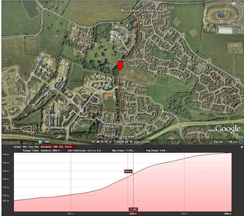
The bikehike.co.uk website works very well but it uses either the 1:50000 OS or googlemaps. Unlike Blew it, I find these sources of elevation are not really accurate enough for my local hills which have slopes which vary between contour intervals. I have used 1:25000 OS which are better since the contour intervals are smaller, 5m. However, I think even these have limitations, since the roads on hills are often not at the same height as the adjacent ground on which the contours are shown on the map. There is often a high bank and the road is in a cutting. So there are likely errors of due to the difference between the road height and that of the adjacent ground.
GPS is another possible source of altitude intro, but I find this to be quite a bit less accurate than the best 1:25000 OS map data.
All in all, Flecc's method, or the digital inclinometer seems to offer the most accurate data for hills with slopes that vary.

")