Okay I know ill get hit with rational regarding you just get out there and work it out xyz but I like being efficient/thorough as people are already starting to see ! So without further ado:
love this gent! Perfect example of how powerful tools like Trailforks, Alltrails and other apps can be. it also shows how he could have got lost a few times too bumbling about, this is what I want to remove basically, cba bumbling! Im still checking and Kamoot seems to have the best navigation but I can’t seem to search for trails easy at all unless it’s by their recommended ones in the blog sections...ideally I could export the gpx into kamoot but don’t think you can.
So then I synced from TF to my Garmin edge and the map showed up nice and easy In the garmin TF app. It looks like this:
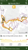
the above us Trailforks, just perfect!
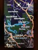
Here is the stripped down Garmin version
In the TF app some amazing human created a full loop of all the best parts, I could literally hit start.....ah but no you can’t as ofc TF has no navigation, great! So then you save the route and then sync it to the garmin and off you go.....ah but you lose all the metadata and now everything is just a blue line, no red, black data......great again!
So three questions:
1) is there a phone app that can carry its metadata into a nav tool without losing info?
2) is there a way to send app maps to a garmin or another device with all the metadata intact?
3) if garmin is the way is it just some kind of img file that’s missing maybe or something I’m not doing right?
If Trailforks just had that nav and added in some gamification (google SAPS system) it would be far better, I don’t see anything doing what I’m looking for which I’m surprised atm; I’m really not asking for much
So then I synced from TF to my Garmin edge and the map showed up nice and easy In the garmin TF app. It looks like this:
the above us Trailforks, just perfect!
Here is the stripped down Garmin version
In the TF app some amazing human created a full loop of all the best parts, I could literally hit start.....ah but no you can’t as ofc TF has no navigation, great! So then you save the route and then sync it to the garmin and off you go.....ah but you lose all the metadata and now everything is just a blue line, no red, black data......great again!
So three questions:
1) is there a phone app that can carry its metadata into a nav tool without losing info?
2) is there a way to send app maps to a garmin or another device with all the metadata intact?
3) if garmin is the way is it just some kind of img file that’s missing maybe or something I’m not doing right?
If Trailforks just had that nav and added in some gamification (google SAPS system) it would be far better, I don’t see anything doing what I’m looking for which I’m surprised atm; I’m really not asking for much
Last edited: