Hill gradients!!!!! Again :)

Jimod

Esteemed Pedelecer
Aug 9, 2010
1,065
634
Polmont
OK, I've been reading on here about gradients, I've even now made a small home-made inclinometer as per Flecc's instructions.

So, here's my question. If a hill is 20 feet long and rises 2 feet in that distance, that is a 10% hill, right?
The reason I'm asking is, my living room is 22 feet long so if I climbed from the floor to just over 2 feet over that length that would be 10%? It doesn't look too steep. Is 10% considered steep? or am I measuring it wrong? I'll be out next week with my inclinometer as I came to a hill on the bike which I consider steep and I want to check it.
 

funkylyn

Esteemed Pedelecer
Feb 22, 2011
3,172
27
South Shields, Tyne & Wear
No, Jim, 10% isnt a steep hill.

But, say, a 1 in 4 hill IS steep. .....going up 5 feet in every 20......
I think......but its a bit late tonight for my brain to work well maybe I have got it wrong too :D

Lynda :)
 

Jimod

Esteemed Pedelecer
Aug 9, 2010
1,065
634
Polmont
The hill I'm determined to measure IS steep. :) Hence my home-made inclinometer. :)
 

flecc

Member
Oct 25, 2006
53,559
30,848
That's correct, 10%. A 10% hill isn't terribly steep, indeed I say that's where hills start, everything below I call a slope.

On a small scale as in your room, inclines do look quite shallow, but when riding up them the impression can be very different. The photo below shows a 14% hill where the bike is (the pavement is steeper), and the horizontal lines of the brick wall show the photo is level for accurate comparison with the slope:


muckymits

Esteemed Pedelecer
May 31, 2011
419
2
I live on top of a 14% it looks steeper than Fleccs pic and certainly feels like it even to drive up ;)
 

jazper53

Esteemed Pedelecer
Jan 20, 2012
890
18
Brighton
I use the old fashion method, if i am gasping for air and become delirious by the time i get to the top i tend to grade that as steep. just joking
 

flecc

Member
Oct 25, 2006
53,559
30,848
I live on top of a 14% it looks steeper than Fleccs pic and certainly feels like it even to drive up ;)
Same as me, that's the hill I live up and measured accurately. The catch is that photos always look hills look less steep than they seem when actually climbing them.
 

10mph

Esteemed Pedelecer
Dec 13, 2010
351
0
England
I'll be out next week with my inclinometer as I came to a hill on the bike which I consider steep and I want to check it.
I have found the inclinometer method to be very accurate. I used a 70 cm long builders spirit level. But it takes a lot of work to get a full hill profile. Flecc's method of taking a photo of roadside building works well: relying on the builder to have used a good level to lay his bricks is an excellent method to get a spot reading of the gradient. The picture needs to be taken square on to the roadside building to avoid distortions which would result in errors. Sometimes I have even been able to use Google Street View to get an idea of slope, but care is needed because of distortions in the Google images.

I previously posted a profile of a nearby steep hill (13% so only just a hill rather than a slope according to Flecc - but I call it steep!). Unfortunately that post was on one of the threads that got temporarily removed 6 weeks ago and still has not been restored, so I will post that profile again.

I had to take 20 inclinometer readings in order to be able to see how the slope varied on the hill - the green points and line. I then worked out the height gain beteen each inclinometer reading and produced a hill profile - the yellow points and line. Finally as a check I looked at the 5 metre interval contours on an OS 1:25000 map and produced the blue points and line.

I was reassured that the inclinometer method and the OS map agreed that hill was 35 metres high.

The contour method can easily be a few metres in error if the road is in a cutting or on a bank - generally the OS contours are correct at the surface of the surrounding terrain.

I have also used altitude from a GPS but the errors are much greater: OK for total height gain on a high hill, but not reliable for details of the slope on the above hill. I have also tried Google Earth and usually find it to be much worse than the OS contours method.

In conclusion, the inclinometer is the most accurate method, but you do need a reasonably smooth - non pot holed road surface, or else use the inclinometer on a long plank.
 

Attachments

flecc

Member
Oct 25, 2006
53,559
30,848
Here's another photo of my 14% hill from an entirely different angle which does make it look rather steeper than the one I posted above, though the trailer is at about the same point of the hill. The parked cars help show the incline:


Geebee

Esteemed Pedelecer
Mar 26, 2010
1,256
227
Australia
This is a local hill about 35% grade, and no I have not yet ridden up it, down it yes :)
 
Last edited:

Geebee

Esteemed Pedelecer
Mar 26, 2010
1,256
227
Australia
A couple of km away from my house, Hobart, Tasmania, Australia.
It has hand rails to assist walking :)
 

10mph

Esteemed Pedelecer
Dec 13, 2010
351
0
England
Very careful measurement of angles is required

This is a local hill about 35% grade, and no I have not yet ridden up it, down it yes :)
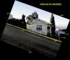
I was impressed by the picture of your very steep looking hill in Hobart, but on careful inspection and after measurements of the angles in your photo I have come to the conclusion that the portion of the hill which you show is not 35% but close to 20% or 1 in 5.

As I posted earlier in this thread,
Flecc's method of taking a photo of roadside building works well: relying on the builder to have used a good level to lay his bricks is an excellent method to get a spot reading of the gradient. The picture needs to be taken square on to the roadside building to avoid distortions which would result in errors.
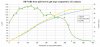
Here is what I got when I measured the angles using photoshop:


I have assumed that the builder constructing the white house used an accurate spirit level to make the window frame and the horizontal planks exactly horizontal. We see that at the eave level the angle is -1.3 deg, the cross bar of the window frame -3.4 deg, the window cill -5.2 deg, and the plank visible near the ground -5.9 deg. There is clearly some distortion or skewing in this photograph, since if measured with a spirit level we would expect all these angles to be the same.

I have made two estimates for the slope of the hill:
Using the handrail slope: I have measurements of -17.9 deg and -16.8 deg, which gives an average of 17.35 deg. but the window cill which intersects this line gives -5.2 deg, so the handrail slopes at 12.15 deg relative to the window cill. This gives a handrail gradient of tan(12.15) = 19.3%.
Using the road kerb slope: I have measurements of -19.1 deg and -18.7 deg which give an average of -18.9 deg. Noting that the skew increases as one moves towards the bottom of the picture I have taken the horizontal to be the -5.9 deg at the bottom plank and assume it would change to -6.1 deg a little lower in the picture. This now gives the angle of the kerb relative to the horizontal to be -13.0 deg and the gradient of the hill is tan(13)= 20.7%.

I then took the average of these two estimations of the gradient and concluded that this portion of the hill is 20% or a much more rideable 1 in 5!
 

Attachments

Last edited:

Geebee

Esteemed Pedelecer
Mar 26, 2010
1,256
227
Australia
Here is the original picture taken with a phone camera, I just put it into gimp and the hand rails and house verticals both come up as 20 degrees in Gimp when rotated to line up with the grid (after leveling the road to horizontal initially), whch comes up as ~36% grade.
I would not take to much notice of variations on the house itself as its build quality is not great :)
 
Last edited:

10mph

Esteemed Pedelecer
Dec 13, 2010
351
0
England
Geebee: I still dont agree. In the original picture the house "horizontals" are still not parallel, e.g. in your latest picture it is obvious that the window frame is not rectangular. Using this un-rotated picture I still get around 20% gradient.

So what options do we have to resolve this disagreement?

  1. I think Tasmanian house builders are likely to get their horizontals horizontal to within a degree. If the window frame were that far off rectangular then the glass cut with aid of a set square would not fit! So can you creep up to the house's front window with a spirit level and check whether the cill is indeed horizontal?
  2. Can you take a picture of some building in Hobart known to be accurately square? Ideally have the phone camera on the same zoom settings if it is adjustable. This would test for distortions in your phone camera lens. Alternatively are there other squarely built houses on the hill which you can photograph?
  3. Can you provide the exact street name so I can try and check it using Google Earth? Google Earth does not have accurate elevations everywhere, but it would be worth a try as it ought to show up the difference between a 20% slope and a 35% slope. Alternatively, can you get a local topographic map with a contour interval of 10 metres or even every 50 feet?
  4. Failing all the above I would love to follow bode's advice below,
    Off you go, then! (Rather you than me.)
    The closest I have ever got to Tasmania was standing on the very tip of Wilson's Promontory looking out over the Bass Strait and being felt drawn to the land beyond the horizon to the South. When we subsequently arrived in Melbourne, there were tourist trips advertised to Tasmania, but alas there was a lack of time and the attraction of the Great Ocean Road drew us westward. So I will never make it to Hobart unless of course I start an appeal on this forum for funds to send me and my bike to Hobart to tackle the hill. The fund would have to be great enough to enable me to upgrade my 3 speed Agattu to one of the 2012 Impluse model 8 or 11 speed versions. I would not want to go all that way and risk ignominious failure to surmount the hill.