Done another test on the Pro Connect today.
13 mile hilly trek, with a stop for a pint.
lost 3 lights on the battery this time.
The bike was on high power all the way.
The other 2 lights would have proabaly given me a range of 21.66 miles.
Conditions.
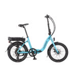
Pro Connect.
18 sprocket rear mod.
Male 13st 7lbs (getting fitter)
10lbs Pannier.
Good headwind today.
Hot and humid.
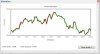
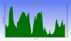
As you can see Sheffield is all up and down.
Regards Bob.
Total ascent was 1115.41 feet.
Just to note, this thing still powers up mostly any hill I've thrown at it.
Theres just one very steep one and im gonna give it a go when im fitter.
Hope someone may find this interesting.
13 mile hilly trek, with a stop for a pint.
lost 3 lights on the battery this time.
The bike was on high power all the way.
The other 2 lights would have proabaly given me a range of 21.66 miles.
Conditions.
Pro Connect.
18 sprocket rear mod.
Male 13st 7lbs (getting fitter)
10lbs Pannier.
Good headwind today.
Hot and humid.
As you can see Sheffield is all up and down.
Regards Bob.
Total ascent was 1115.41 feet.
Just to note, this thing still powers up mostly any hill I've thrown at it.
Theres just one very steep one and im gonna give it a go when im fitter.
Hope someone may find this interesting.
Last edited:
")